


Many books have been written about the best place to ambush a big buck… I know because I wrote 2 myself. The following article is actually taken from a chapter in my book “The Whitetail Hunter’s Blueprint”.
Using Topo Maps, aerial photos, and satellite programming in conjunction with GPS provides the most useful tools to decipher where to begin scouting. I use this info to provide the what, how, and where I will need for my hunting area.
Let’s discuss the differences and benefits to the most common landscape features.
Inside corners
I’m sure by now you have all heard at one time or another to hunt inside corners. Figure #2 is an example of an inside corner on an aerial photo. This is by far one of my favorite stand sites in agricultural type settings.
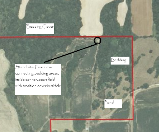
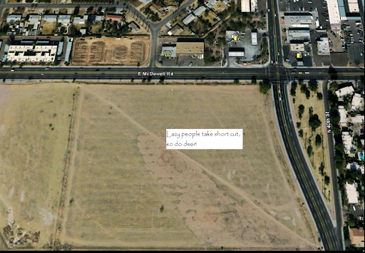
Deer will often use these corners as a travel route because it is the shortest distance between two points and they are lazy. If you go to a park that has high foot traffic, you will notice where one sidewalk meets another at a 90-degree angle there is often a worn path where lazy people cut the corner instead of following the sidewalk. Well, deer do the same thing. See figure #3. I have also discovered that deer often enter fields via inside corners because it allows them to see a larger portion of the field while staying in cover.
Moreover, the spoils of agriculture are often left in tight corners that large combines or machinery cannot easily access. So it becomes a mini food plot.
These areas are great places to begin scouting. If you can find an inside corner that has two intersecting fence lines forming a point it will be an even better location. I have killed more bucks along fence lines than any other feature. Nothing directs deer movement more readily than a fence. See figure #4.
Fence lines
Fences are found almost everywhere. Even in wilderness areas, there are often fence lines that were created for open range cattle control or for boundary markers. Americans love fences. However, they are not always depicted on maps, especially within timber. Thus, careful examination of photos provides the best chance to locate one of these “Buck Factories”.
In that same vein, an inside corner that has intersecting fence lines will often create a crossing point for deer. You can help this along by creating one. You simply cinch the top and bottom wire together (see the tips section of my book to find out how). This crossing point further pinpoints the location for hanging a stand. You will often find several trails leading to the crossing point. This is obviously a good sign.
Often the trails converge well before the fence line, and such a converging trail may be a good stand site as well. Careful investigation with the use of trail cams will give you the info you need to decide. However, staying on the fence crossing is typically more productive because it gives you the opportunity to harvest a field edge buck. This is a buck traveling along the edge of the woodlot that is basically walking the perimeter of the field. Also, the wind may be a little easier to play with only one trail to watch.
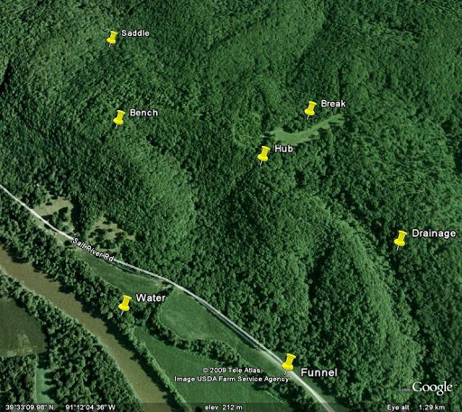
Fence lines, in general, are often very productive. Deer encounter fences at some point in their travels and will often follow along the fence until they come to an easy place to cross. When I hunt out west or in big timber, fence lines will often produce great stand locations. If you add other structural features in conjunction with fence lines, such as benches, saddles, river bottoms and/or funnels the production level increases.
Additionally, a fence that separates bedding from feeding areas will often have heavy traffic at low points and breaks in the fence. In arid regions, water holes sometimes have fences around them. Low points or breaks at these locations are definite stand spots. To clarify: a stand in this context is not limited to tree-stands. It also includes blinds and posting spots. A stand to me is a place where I post and wait for animals to come.
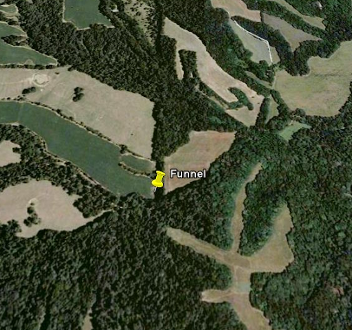
Funnels
Another really productive stand site is a funnel. Now, there are many different landscape features that can be considered a funnel. I will touch on the three most common.
1 – Woodlot funnel
See figure #5. This is a strip of cover 10 to 100 yards wide that connects to large woodlots. Deer crossing from one lot to the next get “funneled” into this narrow strip providing an interception point.
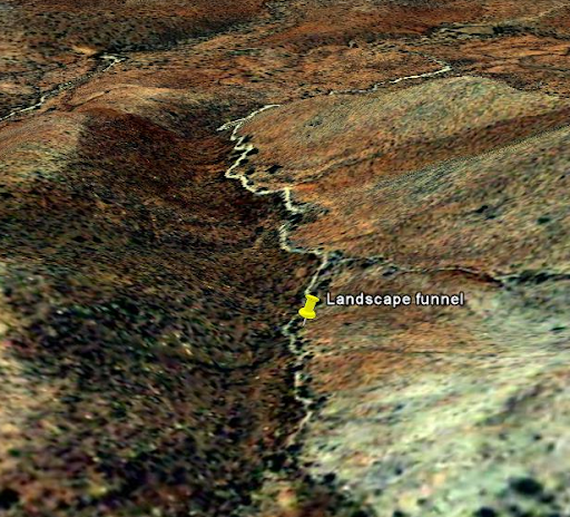
2 – Landscape Funnel
See figure #6. This is where topography, such as a wash, creates a physical funnel that deer will use because it is easier walking for the deer. Hilltop fields or pastures often have this characteristic leading up from a creek bottom or lowland wood lot below.
3 – Field Funnel
This is better described as a peninsula of trees jutting out into a field that deer feed in. See figure #7. Deer often enter fields through these funnels so they can investigate from cover as long as possible. Also, to minimize the time spent out in the open they use these peninsulas to cross the field since it is the shortest point between cover.
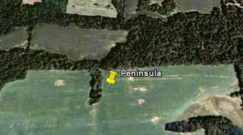
Investigation of these areas will more often than not produce favorable sign, and a good stand site.
Saddles
Saddles also play into the lazy deer theory. These are low points in ridge lines that offer the easiest place for a deer to cross from one side of a ridge or mountain to another. In really hilly terrain these are very good interception points since there are often several trails that converge into one trail to cross over the saddle. See figure #8 for an example of a saddle. Wind plays an important role with saddles because the wind will often be multi-directional; meaning it may be blowing from north to south but will often create a swirling effect and carry your scent back the way the wind was coming from. This is evident in many hilltop set-ups.
I for one don’t pay a whole lot of attention to the wind, and people call me foolish. However, it is not my main priority because I put painstaking detail into my scent eliminating regiment. Plus, I often set my stand in a spot that if the wind changes I still have opportunities to harvest a buck. I am not, by any means, saying don’t use the wind to your advantage. If I didn’t think the wind was important I would not have included a section on it in my book. What I am saying is the wind is unpredictable, so be detailed in staying scent free and choose your set-ups wisely.
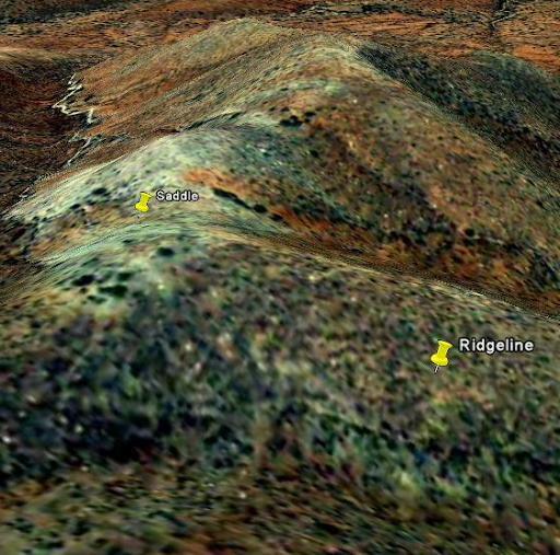
Saddles are often formed by intersecting ridge lines. A ridgeline will almost always have a trail at the very top of the ridge. When you have two ridges coming together at a low point or “saddle” you will often have higher traffic in those areas because you have 4 main trails converging. Sometimes possibly more if there are benches transecting the ridges. See figure #8.
Benches
A Bench is a relatively flat spot on the side of a mountain or ridge that runs parallel to the ridge itself. Benches create an easy walking path for lazy deer. Also they are often a bedding area if the ridge overlooks more open terrain. I personally do not like hunting benches themselves, but I do like to locate them and follow their trails back to cover or to feeding areas. As I mentioned earlier, the bench trails may also lead up to the converging ridgeline trail and saddle trail.
Edges
These are the big wood hot spots. There are many different types of edges by definition since they are where one type of terrain meets another. An example is when a wooded area meets a swamp, or when a burn meets timber.
Before man started altering the whitetails landscape, Mother Nature created edges and breaks with fire, wind, and water. These breaks provide the best food sources for wild deer. Previously, deer did not have what has now become a “natural” food source for them – our agriculture. However, in areas void of agriculture and excessive human involvement, it is these areas that deer rely on for food and cover.
Living in the western United States for my adult life, it was an adjustment learning to locate deer in timber and areas otherwise void of agriculture. Coming from the east, we hunted mostly farmland and areas that had 30-40 deer per square mile. In the west, there are often 10 deer or less per square mile.
I learned to glass and stalk for deer instead of intercept deer. Through these experiences I realized I would almost always find deer on the edges of 2-3 year old burns, logging clear cuts, riparian areas, and in areas where ponderosa pine transitioned to oak scrub or juniper stands. This got me to investigate those areas closer. I began looking for ways to intercept these seemingly “pattern-less” deer. I would often sit and watch deer for weeks leading up to hunting season to get an informed idea where I could set up a blind or stand.
Now, not all of us have weeks to spend watching deer movements. So, hunting the big woods, edges, or breaks can be just as good as hunting a food plot, if you choose the right one.
Burns and clear cuts about 2 years old to about 5 years old, depending on rainfall and winds, provide very good places to begin looking for sign. Riparian areas will almost always have game sign because of the constant new growth and water. Swamp edges also provide good areas especially when there is a large break in the tree canopy.
The one drawback to edge hunting and clear-cut hunting is the limited availability of locating information. Since you cannot locate breaks on a topo map, and unless Google has done a flyover of the area you want to hunt, you may not have the info you need. You can sometimes find out from BLM or forest service agencies if there has been any logging in the last few years in your hunting area. Keep tallies on small forest fires, mark their location, and watch them to see if they grow up into the vegetation type you need to attract game.
Now that you are armed with the info you need to build your game plan, hit the field and scout these areas. There is no substitute for boots on the ground. Try to stack as many terrain features you can in your favor, hang some cameras, choose a tree, and send EHUNTR a pic of your buck.